
Epic Martian landscapes, wide-open views, and a runnable volcanic ridge
Japan’s Aso Volcano is one of the largest calderas in the world—and this 14.9 km loop lets you experience its raw volcanic power up close.
From sunasenrigahama, the scenery feels like you’ve stepped onto a different planet.
If you love wide-open ridgelines, dramatic craters, and unique volcanic terrain, this is one of the best hikes in Kyushu.
Contents
1.Highlights
1. Otherworldly landscapes
Sunasenrigahama and the Naka-dake crater look nothing like Earth.
Black volcanic ash, steaming vents, and huge rock fields create a true “Martian” vibe.

2. Continuous panoramic views
With almost no vegetation, the views stay wide open for the entire ridge.

3. Surprisingly runnable sections
Once you reach Minami-dake, the ridge to Naka-dake and Taka-dake is almost completely flat—perfect for trail running.
2.Course Overview
Distance: Approx. 14.9 km
Total Elevation Gain:1,022 m
Estimated Hiking Time: 6 hours 59 minutes
Difficulty: Intermediate
Best Season: Spring–Autumn
Start / Finish: Aso Sanjo Terminal
Peaks Covered: Saruyama (1,303 m), Minami-dake (1,496 m), Naka-dake (1,506 m), Taka-dake ( 1,592 m)
Convenience Store: None
Toilets: Aso Summit Terminal
3.Access
By Car
Park at Aso Sanjo Parking (free).
You can drive up to the crater viewpoint (paid toll), but hiking from the lower lot is recommended.
By Bus
A bus runs from Aso Station to the Aso Summit Terminal. You can find the timetable here.
4.Safety Notes
Aso is an active volcano, and conditions change fast.
Crater access may be restricted depending on the alert level. Check the latest alert information before your hike.
And strong winds are common, especially around the crater rim.
In fog or volcanic gas, route-finding becomes difficult due to limited markers.
And there are no bears living in Kyusyu, so bear safety measures are not necessary.

5.Trail Report
Start: Aso Sanjo Parking

I began from Aso Sanjo Terminal.
A few years ago, crater access was closed due to high alert levels, so I was excited to finally visit Naka-dake again.

Cross the gate and head toward Sara-yama (Sarayama).
Sara-yama → Sunasenrigahama → Minami-dake
The terrain becomes barren almost instantly.

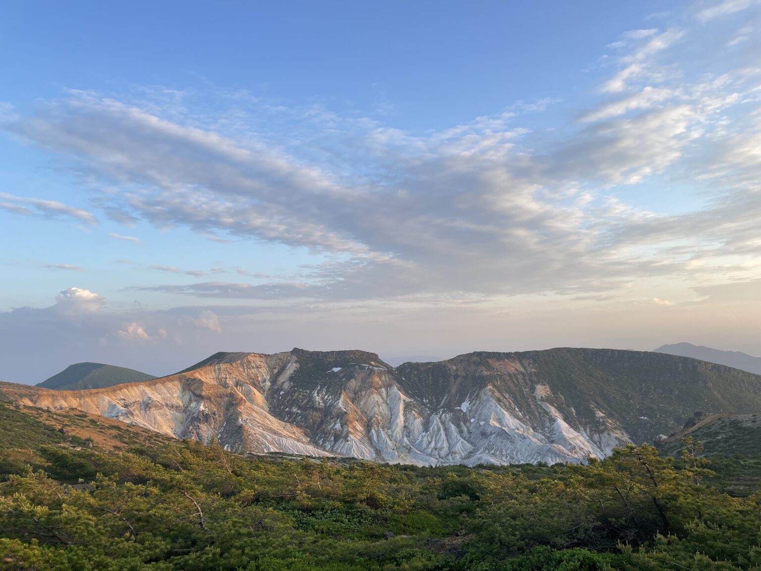
I didn’t expect much from Sara-yama since it felt like a small bump on the map, but the view toward Naka-dake from here is amazing.
The major route to Naka-dake goes through Sunasenrigahama, but I recommend taking Sara-yama route instead.
You can see both sunasenrigahama and the Naka-dake.

Descend to Sunasenrigahama and continue toward Minami-dake.

This section features scattered lava rocks and fault lines—volcanic geology on full display.
The climb is steep and rocky, not ideal for running, but rewarding.
Minami-dake → Naka-dake → Taka-dake
Once you reach Minami-dake, the trail becomes beautifully flat. Perfect for running!

The views stay open as you approach Taka-dake.
At the summit, a massive crater bowl spreads beneath you—like looking into a giant cauldron.
We decided to do a crater loop while we were there. Many people head back after reaching the summit of Taka-dake, but the East Peak is also a great view.
If the weather is foggy, this section can be tricky since there are few landmarks.
Taka-dake → Crater East Viewpoint (Hardest Part)
Heading back toward Naka-dake, descend to the East Crater Viewpoint.

This descent is steep and very windy—easily the toughest part of the course.
The volcanic sand blasts your face, and the gusts feel strong enough to push you over.
But the view is absolutely worth it:

the crater looks unreal, like something between Mars and the Moon.
And surprisingly, it’s much less crowded here than at the summit.

The view is so so incredible that I ended up taking way too many photos. (I checked later and realized I had taken more than 30 shots just at this spot-oops!)
From this spot, Sunasenrigahama looks almost like a glacier, probably because of the volcanic ash.

Sunasenrigahama→ Aso Sanjo Parking
Climb back up to Naka-dake and descend toward Sunasenrigahama.

Once we got back to Naka-dake, the wind finally calmed down and I was able to take my hood off.
I guess the strong wind earlier was because of the crater.

This ash-covered plain feels like a “planet of sand.”
Follow the wooden boardwalk before reconnecting with the road.

We stop by the No.1 Crater viewpoint—the emerald crater lake is stunning (around 60°C, so definitely not for bathing!).
Return to Aso Sanjo Parking to complete the loop.
6.Trail Running Tips (For Runners)
Best runnable section: Minami-dake → Naka-dake → Taka-dake ridge

Avoid running: steep ascent to Minami-dake
Gear: wind shell essential, perhaps sunglasses recommended (sand hits HARD)
Shoes: sturdier than regular sneakers (because the trail has rocky and sandy sections).
7.What I Learned on This Trail
If I had to describe it in one word: otherworldly.
It’s hard to believe a place like this exists on Earth.
I’ve learned about things like the Big Bang and dinosaurs in school, but they never felt real to me.
But walking this trail and seeing the landscape made me think, “Maybe those things really did happen long, long ago.” It’s hard to put into words, but this is one of those rare places where you can truly feel the Earth’s energy—something you don’t notice in everyday life.
And I have to say it again: the East Crater Viewpoint is absolutely worth visiting.

The scenery is breathtaking—beautiful, but with a touch of something wild and a little scary.
The wind is especially strong there, and it honestly feels like the Earth is alive.
You’ll also pass scattered lava rocks and visible layers of volcanic ash along the trail, which makes it even more fascinating.
If this hike makes you want to explore more, here are my favorite trails in Aso and Kuju.
And you can also check out recommended trails, climbing spots, and other activity areas across Japan here!